Archive for the ‘Geography’ Category

The geography of population

January 25, 2023

According to the editor of the Brilliant Maps, web site, this circle not only contains half the world’s population, it also contains:

  • The highest mountain (Everest)
  • The deepest ocean trench (Mariana)
  • A majority of the world’s Muslims, Hindus, Buddhists and Communists.
  • The world’s most sparsely populated independent nation (Mongolia)

Below is the circle that contains the largest possible number of the world’s people.  It is not greatly different from the circle that contains the largest possible acreage of the world’s land area.  Geography, it seems, is Euro-centric.

However, the world’s population center – the point on the earth with the shortest average distance to every person on earth – is believed to be somewhere in Central Asia or northern South Asia.

And here is a map that will enable you to figure out how many people live on your half of the world.

If you click on the links, you can get enlargeable versions of these maps.

More People Live Inside This Circle Than Outside It on Brilliant Maps.

How Much of Humanity Is on Your Side of the World? on Brilliant Maps.

Book note: A journey around Russia

April 13, 2022

THE BORDER: A JOURNEY AROUND RUSSIA through North Korea, China, Mongolia, Kazakhstan, Azerbaijan, Georgia, Ukraine, Belarus, Lithuania, Poland, Latvia, Estonia, Finland, Norway and the Northeast Passage by Erika Fatland (2017) translated from the Norwegian by Kari Dickson (2020)

Russia is the largest country in the world, and has the largest border.  The circumference of Russia is half again as large as the circumference of the globe itself.

A young Norwegian woman named Erika Fatland circumnavigated Russia, which is no small feat, and wrote this book about it.

She visited every country on Russia’s southern and western borders. She saw the sights in each country, talked to some of the locals and brushed up on the history of its relations with Russia.  

Every one except Norway bore the scars of having been attacked or occupied by Russia at some point in its history, most of them in the 20th century.

The implication is that there is something about Russians that makes them a standing threat to their neighbors, no matter whether they are ruled by Tzars, Communists or Vladimir Putin.

I don’t agree with this framing.  Russia itself has been attacked and invaded many times.  And, like the 18th century conservative Edmund Burke, I know not the method of drawing up an indictment against a whole people.  

Even so, I found the book worth reading.  I learned interesting things from it.  I thank my friend Judith Judson for recommending it.

 It is too big to summarize.  I’ll hit some high points.

Fatland’s first stop was North Korea, whose existence is a reminder that totalitarianism is real.  People there have less freedom than an American or Briton in prison, yet they think they are free.  They are poor and backward, yet they think they live in the most advanced nation in the world.  

Or so they said.  But maybe the system of surveillance is so complete that many or most North Koreans inwardly have doubts, but don’t dare to say so.  The result is the same.

Back in the 1950s, many of us liberals feared that totalitarian governments could come to dominate the world and establish a complete system of thought control.  North Korea shows that danger wasn’t altogether imaginary.

I found Fatland’s account of Mongolia was the most interesting section of the book.  Mongolia adopted Tibetan Buddhism in 1586 and their spiritual leaders came from Tibet.  But the prediction is the next Mongolian lama will be incarnated in Mongolia.   Fatland heard a Mongolian throat singer, who’d mastered the art of singing in two tones.  

She interviewed reindeer herders in Tuva, the remotest part of this remote country.  She talked to “ninja miners,” individuals who prospect for gold and other minerals in this mineral-rich country.

Kazakhstan is a prime example of Soviet and Russian imperialism.  Along with the other Central Asian nations, its government is a continuation of the Soviet government and it is under the thumb of Russia.  An uprising a few months ago was quashed with the help of Russian troops.

(more…)

Some things I just learned from maps

January 8, 2022

How the Netherlands expanded by reclamation from the sea

.

Annual hours of sunshine in Europe and the USA

.

The wandering North magnetic pole

(more…)

Can you name the missing seven states?

December 12, 2020

Via XKCD. Hat tip to kottke.org.

Fantasy League U.S. presidential elections

March 1, 2019

Click to enlarge. Source Philip Kearney Cartography.

Could Bill Clinton have beaten Donald Trump?  Could Ronald Reagan have beaten Barack Obama?  Who would have won if Bill Clinton had somehow been able to run against Hillary Clinton.  George H.W. Bush, the elder, against George W. Bush, the younger?

A cartographer-blogger named Philip Kearney calculated hypothetical results, based on the percentage of the popular vote each candidate won in each state the first time they ran.  The answers to the questions are “no,” “no,” “Hillary” and “Bush 41.”

(more…)

Most human beings live in Asia

September 19, 2018

Double click to enlarge or click on Our World in Data

Max Roser’s Our World in Data published a population cartogram map of the world that’s a good corrective to a Euro-centric or USA-centric view of the world.

Some highlights:

More people live in Asia than live in the rest of the world put together.

More people live in Africa than live in North and South America, with Australia, New Zealand and the islands of the Pacific thrown in.  But that’s fewer people than live in either India or China.

As many people live in the greater Tokyo metropolitan area (38.3m) as live in all of Canada (37m)

As many people live on the island of Java (145m) as live in all of Russia (144m).

More people live in Ethiopia (107.5m) or the Philippines (106.5m) than live in any European country except Russia.

More people by far live in Nigeria (195.9m) than in any European country including Russia.

More people live in the Indian state of Utter Pradesh (220m) than in any two European countries put together.

More people live in Thailand than live in France.

More people live in Uzbekistan (32.4m) as live in all the Scandinavian countries – Norway, Sweden, Denmark, Finland and Iceland – put together (27m)

More people live in the Palestinian territories (5.1m) than live in Ireland (4.6m)

The USA, with 326.8 million inhabitants, is the largest non-Asian nation.  But the nation that declared independence in 1776 numbered only 2.5 million—fewer than today’s Puerto Rico (3.7m), New Zealand (4.7m), Liberia (3.9m) or Israel (8.5m)

Counting squares on the cartogram, the population of England is more than triple the combined population of the rest of the British Isles put together, including Scotland, Wales and Northern Ireland plus the Republic of Ireland.

Max Roser, using United Nations statistics, has data indicating that the world’s birth rates are falling and that at some point around the end of the century, world population will level off.

There’s a question as to whether that level of population will be sustainable, in the light of soil exhaustion, exhaustion of non-renewable resources and the disruptions caused by global climate change.

There’s an even bigger question as to whether that level of population can enjoy the same level of material comfort that I and other middle-class people in North America and Europe enjoy.

The great fear in 1968 when Paul Ehrlich wrote The Population Bomb was mass famine, which he at the time thought was imminent.  But even if that doesn’t happen, a world of greatly unequal populations combined with greatly unequal standards of living will not be a world at peace.

There was a time when we who live in rich countries had the choice of ignoring the more numerous people who lived in poor countries, because they were powerless.  This is no longer true, and will become even less true as time goes on.

LINKS

A Map of the World Where the Sizes of Countries are Determined by Population by Jason Kottke for kottke.org.

The map we need if we want to think about how global living standards are changing by Max Roser for Our World in Data.

World Population Growth by Max Roser and Esteban Ortiz-Espina for Our World in Data.

Future Population Growth by Max Roser for Our World in Data.

What the American land is used for

August 3, 2018

Click to enlarge.

LINK

Here’s How America Uses Its Land by Dave Merrill and Lauren Leatherby for Bloomberg News.  Click on the link for more facts and maps.

Nobody could have beaten Trump (or Clinton)

April 30, 2018

Double click to enlarge.

Source: United States of Apathy by Philip Kearny Cartography.

Hat tip to Lambert Strether on naked capitalism.

Hillary Clinton received 28.4 percent of the votes of eligible voters, Donald Trump received 27.2 percent and 44.4 voted for nobody.   I wouldn’t assume that the 44.4 percent were apathetic.   I’m sure many of them (some of whom had voted in 2008 and 2012) had their reasons for rejecting both candidates.

Nobody got a majority of votes cast.  Hillary Clinton won 48 percent, Donald Trump 45.9 percent and the rest went to small-party candidates.

The revolt of the ‘places that don’t matter’

February 21, 2018

The basic political split, not just in the USA but across the Western world, is between the regions that are thriving under globalization and those that aren’t, according to a new a study.

The thriving areas embrace what I call neoliberalism.  The left-behind areas embrace what Andrés Rodríguez-Pose, the author of the study, calls populism.

In his view, the split between rich regions and poor regions is more politically significant that the differences between rich and poor individuals within these regions.

The split is cultural as well as economic.  The rich regions reflect the culture of what Chris Arnade calls “the front-row kids,” who value education, cosmopolitanism and upward mobility, and the “back-row kids,” who put greater value on family, religion and community.

Rodríguez-Pose uses the word populism to mean any kind of revolt against the economic and political elite, whether in the form of right-wing nationalism or left-wing radicalism.   From his standpoint, they’re both bad.   His solution is wiser economic policies by the political and economic elite.

A populist is one who is on the side of the people against the elite, or claims to be.  The all-important question is how you define “the people”.   Right-wing populists define “the people” in terms of race, ethnicity and heritage.  Left-wing populists define “the people” as the working people.   I think that, in the long run, the only alternative to right-wing populism will be left-wing populism.

LINKS

How the ‘Places That Don’t Matter’ Fueled Populism by Leonid Bershidsky for Bloomberg.

The revenge of the places that don’t matter, but Andrés Rodríguez-Pose for VoxEU, the policy portal of the Centre for Economic Policy Research.

Suicide Rate Highest in Decades, but Highest in Rural America by Mark Maciag for Governing.

The significance of regionalism in U.S. politics

August 4, 2017

Updated 8/5/2017

Click to enlarge

Two things I came to realize from reading Colin Woodard’s American Nations: A History of the Eleven Regional Cultures of North America are how much the various regional cultures have changed over time, but how they still have preserved their separate identities.

One of the most interesting parts of his book is his account of how the various regions were changed by the cultural revolution of the 1960s, but in different ways.

The four Southern regions (Tidewater, Deep South, Greater Appalachia, New France) gave up their resistance to legal equality for African-Americans.  The white political establishment in, for example, North Carolina opposes a reform movement of African-Americans and their white allies, but this is done through normal political maneuvering, not murder and terrorism.   This is a revolutionary change.

Spanish-speaking people in the Southwest (El Norte) and French-speaking people in Quebec (New France) changed from being politically passive and oriented toward tradition to being politically active and oriented toward the future.   I think these changes were set in motion by the new thinking of Pope John XXIII and the Second Vatican Council.

The “youth revolution” in attitudes toward drug use, military service and sexual morality—”acid, amnesty and abortion”—was limited to the Pacific Coast (the Left Coast), the Northeast (Yankeedom and New Netherland), Woodard wrote.

This, too, was a revolutionary change.   A hundred years ago, you could get arrested as a pornographer in Boston for distributing information on birth control.  Now Boston is a stronghold of Planned Parenthood.

Woodard overlooked another transformative 1960s movement—the new conservative movement represented by Barry Goldwater and Ronald Reagan.   The Far West was once the scene of violent labor strikes with battles between armed workers and company police.   Now there are confrontations  between armed right-wing private militias and the federal government.

(more…)

Is Canada a nation?

August 3, 2017

In this post, I consider two authors who argue that Canada is not a nation.

Click to enlage. Source: Cyrus Dahmubed

Joel Garreau, a reporter for the Washington Post, wrote back in 1981 that the USA and Canada were not actually nations, only a collection of regional cultures.

He claimed that their territories were actually divided among The Nine Nations of North America (shown in the left map above), of which only Quebec was wholly contained within the jurisdiction of Canada and Dixie within the United States.

His conclusions were based on travels and interviews in the late 1970s, and he concluded that there really were six Canadian nations, all but one of which had a metropolis in the United States.  They were:

  • New England (Boston), the U.S. New England states and the Canadian maritime provinces.
  • Quebec (Montreal), the actual province of Quebec.
  • The Foundry (Detroit), the industrial region north and south of the Great Lakes and including the U.S. Middle Atlantic States.
  • The Breadbasket (Kansas City), the agricultural U.S. Great Plains and the Canadian prairie provinces.
  • The Empty Quarter (Denver), the thinly populated, mineral-rich Rocky Mountain states and provinces and the Canadian north.
  • Ecotopia (San Francisco), the Pacific-facing region from San Francisco to Juneau, Alaska.

Americans and Canadians within these areas, Garreau argued, had more in common with each other, economically and culturally, than they did with U.S. and Canadian citizens in other regions.

Colin Woodard made the same argument 30 years later in American Nations: a History of the Eleven Regional Cultures of North America, except that, unlike Garreau, he defined all of his “nations” except the Far West based on their cultural inheritance rather than economics and geography.

He divided Canada into six “nations”, at least four of which overlap with the United States.   They are:

  • First Nation, the newly autonomous American Indian nations in the Canadian North.
  • New France, the heirs of the original French settlers.
  • Yankeedom, roughly corresponding on the Canadian side to Garreau’s New England.
  • Midlands, which I will discuss below.
  • The Far West, roughly corresponding to Garreau’s Empty Quarter
  • The Left Coast, roughly corresponding to Garreau’s Ecotopia.

Woodard, who lives in Maine, described the sense of unity between New England and the Canadian Maritime provinces.  The Canadian Maritimes were settled from New England, he wrote, and Yankees and Maritimers were reluctant to fight each other during the Revolutionary War and the War of 1812.

The provinces of Upper Canada (now Ontario) and New Brunswick were created after the Revolutionary War to provide a refuge for defeated Loyalists after the American Revolution.   Most of those Loyalists, according to Woodard, were pro-British fighters, neutral merchants and farmers and Quaker pacifists from the New York City and Philadelphia regions.

Some of them were loyal to the British crown.   Others were attracted by the offer of free land in Ontario—a forerunner of the U.S. Homestead Act.

British, Scots and Irish settlers came in larger numbers to the Maritimes and Ontario, but, according to Woodard, the settlers from the U.S. Midlands came first and it was they who set the tone for the culture.   That is why his hypothetical Midlands region has such a strange, looping shape.

(more…)

Is the American South a nation?

August 1, 2017

What is a nation?  In my opinion, a nation is a group of people who wish to live under an independent sovereign government and whose primary loyalty is to each other.

By that definition, are any of the regional cultures in Colin Woodard’s American Nations nations?

Some North American Indian nations fit that definition.   The French-speaking people of Quebec are a nation; they have achieved virtual sovereignty within the Canadian state.   A certain number of African-Americans and of Mexican-Americans think of themselves as a separate nation.

Woodard described early secessionist attempts in the trans-Appalachian West and talk of secession of New England during the War of 1812, but none of them every came to anything.   There is talk today of secession in California, Texas and other states, but also highly unlikely to come to anything.

The only region within the United States that ever made a sustained struggle to be an independent nation is the American South.

Originally the South, according to Woodard, was not one unified region, nor even two (the mountain and lowland South), but three (which he calls Tidewater, the Deep South and Greater Appalachia).
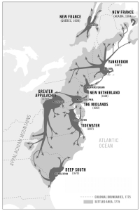
Click to enlarge.

The difference between Tidewater and the Deep South is that the first is that the Chesapeake Bay region was settled by Cavaliers from southern England, who hoped to reproduce British aristocratic rule as it was in the 16th and 17th centuries, and South Carolina was settled by planters from the British colony of Barbados, who intended to establish the slave society of the West Indian sugar islands.

Slavery in the two regions was very different.   The first Africans imported by the Tidewater plantation owners were indentured servants, who had a legal right to freedom after they served their indenture.   Race slavery was introduced only later.

This explains something that puzzled me.   I learned in a biography of Harriet Tubman, who was enslaved in my home state of Maryland, that Maryland in those days had the highest proportion of free black people of any American state.

Click to enlarge.

Later a fellow Marylander, who visited Liberia in his youth as a merchant seaman, said he was astonished at the number of Maryland place names and family names he saw there.

Where did those free Maryland black people come from?

The free black people in Maryland, and the African-American colonists of Virginia, were the descendants of the indentured servants.   Their presence in Maryland and Virginia meant that, even though free black people lacked virtually any legal rights, they still were not quite reduced to the status of livestock.

In contrast, the slave culture of the Spanish, French and British colonies in the West Indies was more like the Soviet Gulag or the Nazi forced labor camps than it was like serfdom in 16th and 17th century Europe.

The West Indian sugar plantations were strictly commercial operations, controlled by a tiny minority of white people, who used terror, torture and the threat of death and mutilation to try to keep slaves under control.   Slaves died at such a rate that the planters needed a continual supply of new slaves to keep operating.

Slavery in South Carolina and the rest of the Deep South was not quite as bad as that, but it was bad enough.   Slaves in Virginia and Kentucky feared being sold down the river to South Carolina and the Gulf states.   But slave owners in the Deep South threatened slaves with being sent to Cuba, which was even worse.

I don’t, of course, intend to justify slavery in any form.  Any time one group of people has absolute power over another, you will reproduce the Stanford prison experiment.

Neither to I intend to imply that Southern white people were all demons or that Northern white people were angels.

Woodard pointed out that there was a time when there were more African slaves in Dutch New Amsterdam than in the region from Maryland to Georgia.   Much of the African slave  trade operated out of Newport, Rhode Island, from which Yankee skippers took trade goods to west Africa, then slaves to the West Indies and then rum back to New England.    The whole newly independent USA  was involved in slavery, not just the South.

(more…)

Is the USA one nation, indivisible?

July 29, 2017

Updated 7/5/2017

Colin Woodard, a journalist and historian, claims that the United States of America is not a unified nation, but an arena of struggle among separate and distinct regional cultures.

For more than 250 years, he wrote, American history has been shaped by the basic conflict between regions he calls Yankeedom and Deep South, and the shifting alliances among the other regions.

Canada, too, is shaped by regional identity.   In fact, neither the United States nor Canada is a unified nation at all, according to Woodard; the real nations of North America are the 11 regional cultures, which are as follows:

  • Yankeedom, heirs of the Puritans of Massachusetts Bay.
  • New Netherland, heirs of the tolerant, commercial Dutch culture of New Amsterdam.
  • Midlands, heirs of the tolerant culture established by Quakers in the Delaware Bay.
  • Tidewater, heirs of the aristocratic culture established by Cavaliers around the Chesapeake Bay.
  • Greater Appalachia, heirs of the original settlers of the Appalachian back country
  • The Deep South, heirs of English West Indian slave owners who settled in South Carolina
  • The Left Coast, heirs of New England Yankees who settled the Pacific Northwest.
  • The Far West, heirs of the varied pioneers who settled this harsh region.
  • El Norte, heirs of the original Spanish settlers of northern Mexico and the American Southwest.
  • New France, heirs of the original French-Canadian settlers and their Cajun cousins.
  • First Nation, heirs of indigenous peoples of the Far North.

I recently finished reading his book, American Nations: the Eleven Rival Regional Cultures of North America (2011), on the recommendation of my friend, Janus Mary Jones.

I think the regional rivalries he described are real.  I learned things I hadn’t known.  But I think he errs in trying to interpret American history exclusively in terms of regional conflict.

(more…)

Why we misjudge the size of nations

July 27, 2017

(more…)

Poverty is hazardous to your health

April 5, 2017

Click to enlarge.

Mortality rate change, 1992-2006.  Click to enlarge.  Source: Daily Mail

(more…)

Concentrations of people and economic activity

March 27, 2017

The USA is a big country.  But its population and economic activity are not evenly spread across the country.

Here are the counties where half the U.S. population lives.

Here are counties where half of U.S. economic activity takes place.

And, below, the counties carried by Hillary Clinton in 2016—in blue, of course.   She carried 88 of the 100 largest U.S. counties.

(more…)

A realistic map of Louisiana

August 22, 2016

Walkable, inhabitable land area of Louisiana

Walkable, inhabitable land area of Louisiana

Southern Louisiana, like the Netherlands, is inhabitable because of the actions of humankind.  Just as the Dutch live behind their ocean dikes, Louisianans live behind their river levees.

Inadequate maintenance of the levees by the U.S. Army Corps of Engineers made the Hurricane Katrina disaster of 2005 worse than it might have been.

map-of-louisiana-citiesThere is a problem with the levees.  Southern Louisiana is part of the Mississippi River delta, built up of topsoil from a huge drainage area stretching from the Appalachians to the Rockies.  The wandering course of the Mississippi deposited this soil over a wide area.  With the levees, the Mississippi is confined to a narrow channel.  This prevents floods, but also prevents replenishment of the delta.  As a result, much of southern Louisiana, including New Orleans, is slowly sinking, creating a need for even higher levees.

There is a good side to this.  Sinking replaces dry land with swamps and wetlands.  Although swamps and wetlands are not walkable or inhabitable, they provide a buffer against ocean flooding by absorbing the water.

It’s complicated.  Global climate change will generate more floods, and make things even more complicated.

LINKS

Louisiana Loses Its Boot by Brett Carrington for Medium.  The source and explanation of the top map.  Also a good explanation of the need for accurate maps.

Taming the Floods, Dutch-style by Damien Carrington for The Guardian.

A realistic map of the Middle East

August 22, 2016

truemapofmiddleeastThomas_Map-01

This map of the Middle East, showing which entities actually control what territory, was published by Frank Jacobs on the Strange Maps web site.  Here’s Jacobs’ key to the map.

  • The Syrian central government (in light grey), based in Damascus, controls a coastal strip of territory in a patchwork shared with a number of rebel forces. The interior of the country is lost to government control, except a single light grey island in a sea of dark grey (for IS): the besieged city of Deir ez-Zor.
  • The ‘official’ rebels (in green) control a fragmented archipelago of territories, spread across the north, middle and south of the country – also concentrated in the east, but without coastal access.  Aleppo, in the north, is on the front line between government and rebel forces, with horrific consequences for the city and its people.
  • Large parts of northern Syria are controlled by the Syrian Defence Forces (in red): a contiguous zone in the northeast, and a smaller zone in the northwest.  Both are separated by the zone of contact between Turkey and Islamic State, although that zone has gotten a bit narrower since the takeover by the SDF of Manbij.  The SDF, by the way, are mainly Kurdish forces, and the area they control is often referred to as Rojava – Kurdish for ‘West’.
  • The Islamic State controls not only the largest part of Syria, but has also spilled over into Iraq, where it dominates mainly Sunni areas in the centre, up to and including the city of Mosul in the north.  The IS’s territory is surrounded by enemies, but has the advantage of being contiguous, with the exception of two exclaves, one in southwest Iraq, and another one in southeast Syria.
  • What remains of Iraq is controlled in the south by the Shiite-dominated government in Baghdad (in light blue), and in the North by the Iraqi Kurds (in yellow).
  • The map also reflects the mainly unrecognised secession of Northern Cyprus (in dark blue) and the de facto secession of Hezbollah-dominated areas within Lebanon (in green) – both facts on the ground predating the Syrian conflict, and likely to survive it.

Source: Frank Jacobs | Big Think

(more…)

The geography of Donald Trump’s support

April 6, 2016


Republican_Party_presidential_primaries_results_by_county,_2016.svg

Winners by county: Trump, turquoise; Cruz, gold; Kasich, green; Rubio, red

Source: Wikipedia.

Trump-Cruz-3-16

Source: The New York Times.

The two maps above show the support for Donald Trump versus other Republican candidates in primaries so far.   The next chart shows support for Trump based on public opinion polls.

upshot_trump_ctr

Source: The New York Times.

None of this has any significance in deciding who to vote for, and little significance in predicting who will win.  It just reflects my addiction to looking at data on maps.

Below are some more maps with information that might help explain these three maps.  First, two maps showing American regional cultures, and then some more demographic information.  I leave it to you to find the correlations (if any).

(more…)

xkcd: Lakes and oceans

January 19, 2016

Double click to enlarge.

Double click to enlarge.

Source: xkcd

Randall Munroe is not just a witty cartoonist and effective explainer.  He is a master of the visual display of quantitative information.   Look at the Deepwater Horizon well on the display to get an idea of just what that was, for example.

A note on population density

December 3, 2015

bCY7Scu

Five percent of the world’s population lives in the blue area on the map. Another five percent lives in the red area. Double click to enlarge.

Source: Max Roser, creator of Our World in Data.

Hat tip to Wait but Why

The 50 United States sized by population

August 31, 2015

States-by-Area---Adjusted---FinalSource: Vox

I hadn’t realized how big New Jersey is in population.  Or Maryland.

Or how much of a disparity there is between Arizona and New Mexico.  And between Vermont and New Hampshire.